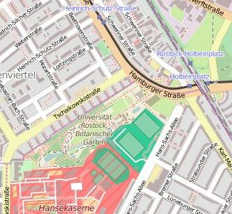
Location of the Botanical Garden
Back in the 1930s, the Botanical Garden was established in its current location in the floodplain of the natural Kayen Mill Creek, which was located outside of the city limits at the time, and was partially built upon small agricultural fields consisting of orchards and fallow land with very fragmented heterogeneous vegetation. Beginning in the 1940s, large residential areas were constructed in the greater area, with the “Komponistenviertel” and the “Hansaviertel” directly neighboring the garden. Since then, due to increased urbanization and the development of the “Holbeinplatz” as a central transport hub, the area surrounding the garden has taken on a more urban character.
How to find us
With public transport:
S-Bahn S1, S2, S3, Trams 1, 2, or 5, or Bus 28 to S Holbeinplatz station
By car:
Parking is available around Hans-Sachs-Allee 49 (18057 Rostock) or Tschaikowskistrasse (18069 Rostock)
Visitors' entrance is located on Hamburger Strasse across from the Holbeinplatz transit station
Delivery entrance is located on Hans-Sachs-Allee 49 (near Holbeinplatz), 18057 Rostock
By clicking on the map section to the right you get to a detailed map of the OpenStreetMap main screen that allows you to orient yourself further.